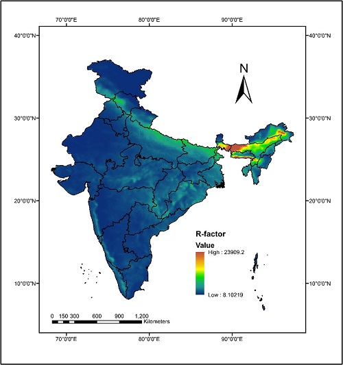
National Rainfall erosivity map for India
Soil erosion induced by rainfall has been a significant global environmental problem. The current assessments of rainfall erosivity in India are limited to catchment or regions specific, which is significantly less to assess rainfall erosivity for a nation like India, having diverse climate properties. About 68.4% of the total eroded soil in India is affected by erosion induced by water, and rainfall erosivity i.e., the potential of rain to cause soil degradation.
Using multiple national and global gridded precipitation datasets, the researchers have developed a high-resolution map highlighting rainfall-induced erosion prone areas in India. The data were obtained from Indian Monsoon Data Assimilation and Analysis (IMDAA) at an hourly temporal scale, India Meteorological Department (IMD) on a daily scale, and the Global Climate Hazards Group Infrared Precipitation with Station data (CHIRPS) on an everyday scale.
The study conducted at Hydrosense Lab, IIT Delhi, by PhD student Ravi Raj, Prof. Manabendra Saharia, and Prof. Sumedha Chakma from the Department of Civil Engineering, has led to the first pan-India assessment of rainfall erosivity over India.

Soil erosion induced by rainfall has been a significant global environmental problem. The current assessments of rainfall erosivity in India are limited to catchment or regions specific, which is significantly less to assess rainfall erosivity for a nation like India, having diverse climate properties. About 68.4% of the total eroded soil in India is affected by erosion induced by water, and rainfall erosivity i.e., the potential of rain to cause soil degradation.
“This study is a step toward building a national-scale soil erosion model for India. The national rainfall erosivity map will facilitate watershed managers to identify rainfall erosivity potential at diverse locations and thereby plan, prioritize, and implement essential watershed development activities to minimize soil erosion,” Prof. Manabendra Saharia, Department of Civil Engineering, said.
According to the study published in the journal CATENA, the average rainfall erosivity (R-factor) value estimated for India is 1200 MJ-mm/ha/h/yr.
The most vulnerable region to rainfall erosivity (R-factor = 23,909.21 MJ-mm/ha/h/yr) was spotted in the Laitknsew and Cherrapunji region of East Khasi Hillis in Meghalaya state (one of the wettest regions in the world). In contrast, the least vulnerable region (R-factor = 8.10 MJ-mm/ha/h/yr) was spotted in the cold and dry Shahi Kangri Mountain region of Ladakh. The study also proposed several empirical equations that field practitioners can use.
Parts of Assam and Meghalaya are among the most significant rainfall-induced soil erosion-prone zones, with mostly loamy, silt loamy, sand clay loamy, and clay loamy textured soil and sloping terrains, not capable of offering much resistance to water-induced soil erosion. The concerned authorities need to adhere to adequate soil conservation measures.
The study has also led to the publication of the Indian Rainfall Erosivity Dataset (IRED), which is freely accessible at https://zenodo.org/record/6470233.
India Science Wire
ISW/USM/IIT Delhi/Erosion-Map/Eng/20/07/2022