Union Minister of Science and Technology, Harsh Vardhan, on Monday launched a new portal called Nakshe, from where topographical maps of various parts of the country can be downloaded by any citizen free of cost.
Developed by the Survey of India, the web application offers the maps in PDF format. Anyone can access it. The only requirement is that a person wanting to download a map would have to login using his or her Adhaar card number.
"A proposal has been sent to Government of Nepal and we are waiting for a response. We hope to get an approval soon", Dr. Vardhan said
The Survey of India has a total of 5,000 topographical sheets. Of them, 3,000 have so far been made available on the web application and 1,300 more are in the process of being uploaded. The balance 700, which pertain to border and other sensitive areas are under review from a security angle. They would also be uploaded once they are approved by the defence establishment, said Dr. Harsh Vardhan.
Speaking to presspersons after the launch, the Union Minister noted that the maps are being made available in public domain in keeping with the National Data Sharing and Accessibility Policy, under which the Government is committed to provide access for all data generated using public money.
The maps are with a resolution of 1:50,000 and are expected to be of particular use to authorities at different levels, starting from the Central Government to talukas and panchayats at the grassroots level in taking forward their developmental work. So far, they had to approach the SOI to get the maps. Now, they can download it on their desktops at leisure without any need for taking permissions.
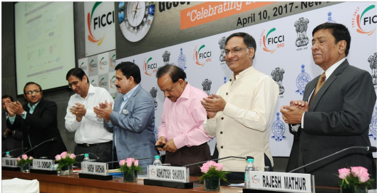
As part of the launch, SOI also organised a day national conference with Federation of Indian Chambers of Commerce and Industry (FICCI) to brainstorm on a geospatial policy frame work for the Union Science &Technology Minister, Dr. Harsh Vardhan, launching Survey of India’s Nakshe map website (photo courtesy PIB) country. Attended by representatives of the geospatial industry, the meet looked at how the Government and the industry could work together to ensure appropriate planning and execution of transformational projects like smart cities and digital India.
Dr. Harsh Vardhan said work on formulation of a policy that would take care of the developmental needs of the country and security concerns in a balance manner is proceeding apace and a draft document would be available for consultation among stakeholders in a few months. The workshop was part of the exercise.
He also noted that SOI was in the process of developing a model that would help utilise GPS data to measure height directly and thus avoid long delays associated with geospatial projects. To begin with, a model is being developed that would be able to convert GPS data into the actual height, which is measured in terms of height above the mean sea level to an accuracy of plus or minus 30 cm. This would be upgraded later to an accuracy of plus or minus 10 cm. An accuracy of 30 cm is more than adequate for most projects except for river basins, where an accuracy of 10 cm would be better. (India Science Wire)